Identity area
Reference code
Bonomi MSS 32.32
Title
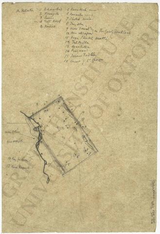
Map of the presumed boundary of ancient Nineveh
Date(s)
Level of description
Item
Extent and medium
1 item
Context area
Name of creator
(1796-1878)
Archival history
Immediate source of acquisition or transfer
Content and structure area
Scope and content
Map of the presumed boundary of ancient Nineveh:
- pencil sketch/tracing with notes on tracing paper
- loose
- 12.5 x 18.2 cm
- [on sketch]
'A Kelata
1 Khorsabad
2 Kounyik
3 E[?]
4 Tell Kaif
B Reshidi5 Kara Kush ruins
6 Karamles ruins
7 Sheikh emir
8 Tergilla
9 Mar Daniel
10 Ain es Sufra } on the Gebel Makloub
11 Deyr Sheikh Matti
12 Tel Billa
13 Bashika
14 Bazaani
15 Imam Fadhla
16 Convent of St GeorgeMar Elias
Yarumjeh
18 Kiz fukura
17 Kara Koyurabi[?]' (pencil note)
Appraisal, destruction and scheduling
Accruals
System of arrangement
Conditions of access and use area
Conditions governing access
Conditions governing reproduction
Copyright Griffith Institute, University of Oxford
Language of material
Script of material
Language and script notes
Physical characteristics and technical requirements
Finding aids
Allied materials area
Existence and location of originals
Existence and location of copies
Related units of description
Publication note
- Bonomi, Joseph, Nineveh and Its Palaces (1852), p. 95, fig. 23.