Identity area
Reference code
Bonomi MSS 32.32
Title
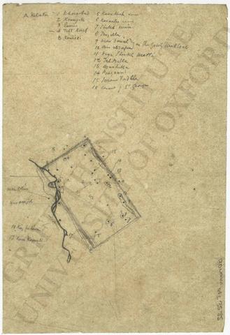
Map of the presumed boundary of ancient Nineveh
Level of description
Item
Extent and medium
1 item
Context area
Name of creator
(1796-1878)
Content and structure area
Scope and content
Map of the presumed boundary of ancient Nineveh:
- pencil sketch/tracing with notes on tracing paper
- loose
- 12.5 x 18.2 cm
- [on sketch]
'A Kelata
1 Khorsabad
2 Kounyik
3 E[?]
4 Tell Kaif
B Reshidi5 Kara Kush ruins
... »
6 Karamles ruins
7 Sheikh emir
8 Tergilla
9
Conditions of access and use area
Conditions governing reproduction
Copyright Griffith Institute, University of Oxford
Allied materials area
Publication note
- Bonomi, Joseph, Nineveh and Its Palaces (1852), p. 95, fig. 23.
Digital object metadata
Filename
Bonomi_32_32_res600ppi.jpg
Media type
Image
Mime-type
image/jpeg
Filesize
202.3 KiB
Uploaded
January 24, 2019 4:12 AM